En
Log in
All resources
Create a design
Tools
38,646 Free Artworks of Map
maps from the earth and its inhabitants, vol. iv
bibliothèque nationale de france
map - museu antônio parreiras
antônio parreiras
maps in the library of congress
drawings in the museu antônio parreiras
british library
paper and graphite
maps from the earth and its inhabitants, vol. xv
maps from the earth and its inhabitants, vol. xviii
maps from the earth and its inhabitants, vol. xv
1870s maps of quebec
maps from the earth and its inhabitants, vol. v
maps of spitsbergen
maps from the earth and its inhabitants, vol. iv
bathymetric maps of the north sea
maps from the earth and its inhabitants, vol. ix
population density maps of the ottoman empire
maps from the earth and its inhabitants, vol. xiv
1870s maps of australia
maps from the earth and its inhabitants, vol. xviii
maps of the indigenous peoples of south america
maps from the earth and its inhabitants, vol. iii
population density maps of germany
maps from the earth and its inhabitants, vol. iv
old maps of bristol
maps from the earth and its inhabitants, vol. viii
temperature maps
maps from the earth and its inhabitants, vol. iv
old maps of sheffield
maps from the earth and its inhabitants, vol. xv
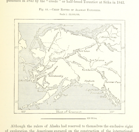
maps of the history of alaska
maps from the earth and its inhabitants, vol. iv
old maps of exeter
maps from the earth and its inhabitants, vol. xvii
maps of native american tribal territories
maps from the earth and its inhabitants, vol. viii
precipitation maps
maps from the earth and its inhabitants, vol. xv
1870s maps of quebec
maps from the earth and its inhabitants, vol. iv
maps of guildford
maps from the earth and its inhabitants, vol. iv
public transport maps of london
maps from the earth and its inhabitants, vol. xi
1870s maps of tunisia
maps from the earth and its inhabitants, vol. iv
precipitation maps
maps from the earth and its inhabitants, vol. xviii
1870s maps of peru
maps from the earth and its inhabitants, vol. xiii
1878 maps of africa
maps from the earth and its inhabitants, vol. xviii
maps of weather and climate of south america
maps from the earth and its inhabitants, vol. iv
old maps of the river thames
maps from the earth and its inhabitants, vol. iv
drainage basin maps of the united kingdom
maps from the earth and its inhabitants, vol. iv
maps of falmouth, cornwall
maps of wissembourg by braun & hogenberg
maps of colmar by braun & hogenberg
old north knoxville historic district
maps in the library of congress
theatri praecipvarvm totivs mvndi vrbivm : liber sextvs (1618)
maps of york by braun & hogenberg
grenzkarte der preussischen, russischen und oestreichischen monarchien (1796)
maps of kovno governorate
sheet 11 of the turgot map of paris
rue neuve-notre-dame (paris)
americae 1562 by diego gutiérrez and hieronymus cock
renaissance
engravings by matthäus merian
baroque
st thomas' hospital (southwark)
guy's hospital
old maps of île de la cité
old submaps of paris
maps from the earth and its inhabitants, vol. x
1890 maps of africa
maps in the phoebus foundation
1662 maps
atlas maior, vol 5 (england) - joan blaeu, 1667 - bl 114.h(star).5
17th-century maps of yorkshire
atlas maior, vol 2 (sweden, russia, poland, eastern europe, and greece) - joan blaeu, 1667 - bl 114.h(star).2
17th-century maps of scandinavia
the cruise of the marchesa (1889)
19th-century maps of borneo
the cruise of the marchesa (1889)
1880s maps of the philippines
maps of paris by braun & hogenberg
georg braun
old maps of the dutch east india company - africa
1665
1747 persia map by emanuel bowen
maps in the library of congress
1805 maps of the united states
maps by john cary
map of brugse vrije by pieter claeissens de jonge
pieter claeissens
eran laor cartographic collection
francesco valegio
drawings in the museu antônio parreiras
paper and graphite
drawings in the museu antônio parreiras
paper and graphite
reconstructions of old maps
german renaissance
drawings in the museu antônio parreiras
paper and graphite
gemeente atlas van nederland - drenthe
maps of borger-odoorn
1800s maps of the netherlands
evert maaskamp
old maps of delft
atlas van loon
demolished churches in de barbari map
san stin (venice)
beschreibung und contrafactur der vornembster stät der welt, liber primus civitates orbis terrarum
maps of rothenburg ob der tauber by braun & hogenberg
travels through virginia (1618)
old maps of virginia
inspection générale des carrières
maps from gallica
old maps of oldenzaal
atlas van loon
media from the national library of finland
classicism
frederic louis norden
maps of nubia
map of amsterdam, 1544
british library
truscott map of st-petersburg 1753
ivan sokolov
turgot map of paris, david rumsey historical map collection – derivative files
historical images of the hôtel des invalides
maps of liège by johannes blaeu - derivative files
old maps of verona
adriano cristofali
maps in the library of congress
1776 maps of new jersey
maps by jacques chiquet
1719 maps of africa
old maps of capitanata
puglia settentrionale
drawings in the museu antônio parreiras
paper and charcoal
drawings in the museu antônio parreiras
paper and graphite
topographischer atlas der schweiz
maps of winterthur quarters
map of the upper rhenian circle by sanson
maps by nicolas sanson
paintings by antônio parreiras in the museu antônio parreiras
paintings of cityscapes by antônio parreiras
paintings by antônio parreiras in the museu antônio parreiras
portrait paintings by antônio parreiras
old maps of koedijk
old maps of alkmaar
old maps of southeast asia
maps by thomas starling
maps from the earth and its inhabitants, vol. vi
georgia in the 1890s
1870s maps of libya
ghadames
maps by john cary
1799 maps
zehn karten und ansichten den schlachtfelden des amerikanischen unabhängigkeitskreiges in den staaten pennsylvanien und new york
maps in the library of congress
zehn karten und ansichten den schlachtfelden des amerikanischen unabhängigkeitskreiges in den staaten pennsylvanien und new york
maps in the library of congress
17th-century maps of africa
maps from gallica
maps in the rijksmuseum amsterdam
18th-century maps of japan
nouvelle géographie universelle, vol. xii
charles eugène perron
bibliothèque municipale de reims, rès. g 152
old maps of abbeville
nouvelle géographie universelle, vol. xii
charles eugène perron
nouvelle géographie universelle, vol. xii
charles eugène perron
buildings in wilhelma zoo
schloss rosenstein
david rumsey historical map collection
1790s maps of the holy roman empire
hamburgische elbkarte von melchior lorichs
parts of old maps of hamburg
landais & oberthur
maps from gallica
17th-century maps of crete
old maps of candia
la rioja (spain) in the 18th century
old maps of la rioja (spain)
maps in the british museum
old maps of leeds
theatri praecipvarvm totivs mvndi vrbivm : liber sextvs (1618)
maps of heilbronn by braun & hogenberg
maps in the library of congress
1773 maps of the united states
atlas minor gerardi mercatoris (1621, maps)
17th-century maps of siberia
the geographical distribution of animals (book)
australasia
coats of arms on maps
1645 maps of belgium
maps from the earth and its inhabitants, vol. iv
old maps of the lake district
16201 - 16300 of 38,646
Next page
/ 387